Software
Purepoint Pro: data processing LiDAR software for use with Auriel and Routescene LiDAR systems.
Contact us todayLiDAR software for complex and extensive data analysis
Purepoint Pro is powerful LiDAR software created so you can easily turn your data into actionable results. The software is specifically designed to process the large datasets captured using LiDAR systems:
- Static data collection: Process and analyse data from systems such as Auriel Record or Auriel Real-time.
- Dynamic data collection: Georeference, clean, reduce, analyse and visualise mapping data captured using Routescene’s LiDAR systems.
- Third party datasets: Analyse existing point clouds or derivatives in industry standard formats such as LAS, LAZ or Geotiff.
Developed by Mapix technologies, Purepoint Pro has been used by customers around the world since 2015 to create 3D spatial outputs from LiDAR data.
Capability for Auriel LiDAR systems
The breadth of functionality in Purepoint Pro enables you to post process the data from Auriel Record to rapidly determine insights and make decisions; and to analyse in real-time the data received from Auriel Real-time.
Purepoint Pro LiDAR software enables analysis of the dynamic environment for smart city, transportation, maritime and waterway applications including:
- Traffic counting: volume and flow
- People monitoring: pedestrian zones, parks
- Footfall at airports, rail and bus stations, ferry terminals
- Crowd monitoring for public safety
- Vessel quantity and size classification in marinas, ports and harbours
- Stock pile monitoring.
Capability for Routescene LiDAR systems
If you need to process and analyse dynamic data collected using Routescene’s LiDAR systems or third party datasets visit the Purepoint LiDAR software pages on the Routescene website.
Benefits of Purepoint Pro LiDAR software
- Windows based desktop application for increased data security.
- Visualise in 3D and colour for easier interpretation.
- Data processing efficiency.
- Post processing analysis.
- Real-time analysis.
- Workflow to save, share and repeat tasks.
1. Windows based desktop application
Processing data locally, rather than on the cloud, improves data security. This is ideal for projects where confidentiality is important and data is not permitted to be uploaded to a cloud service. In addition, Purepoint Pro can be operated for periods of time offline. This feature is useful when undertaking projects in a remote region so you can quality check your data to ensure you have collected the information you need prior to leaving site.
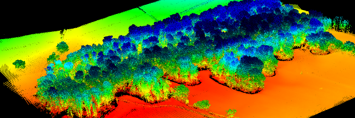
2. Visualise in 3D and colour for easier interpretation
Visualisation tools for easier and better interpretation of the point cloud and to enhance the understanding of the environment being scanned. For example you can apply colour based on range, height, reflectance and laser Channel ID.
3. Data processing efficiency
Use filters, filter chains, layers and workflows to batch process data in real-time or post data collection. Combined with Purepoint Pro’s fast processing speed these features radically improve efficiency.
Filters: A filter applies a specific action to your data e.g. extracts only the data associated with an Area of Interest (AoI), or selects data pertinent to object detection, or collates the results to create an html page.
Purepoint Pro offers over 60+ pre-developed filters ready for you to use to process your LiDAR datasets.
Filter chains: You can join filters together into filter chains to create a workflow. Each workflow being specific to a particular application, and the combinations are endless.
Bespoke algorithms distinct to your project can be developed easily, for example, using python scripts.
Layers: Write the processed LiDAR data to a Point, Raster or Vector Layer to enable an intermediate or final result to be stored prior to further processing or export.
Displaying results: Choose the best output to present your results including a webpage to continuously display the frequency of vehicles passing a point on the road; or a list of the number of pedestrians in a shopping precinct at certain periods during the day; or the number and size of vessels entering and leaving a port.
4. Post processing analysis
Replay your raw LiDAR data time and time again like a streaming video, jump to a point of interest and select the relevant section to analyse in detail. Apply filters and filter chains to the section of raw LiDAR data to create digital outputs and actionable results.
The processing can be as simple or as complex as required to analyse the data and achieve the results you need.
5. Real-time analysis
Install Purepoint Pro on a desktop PC or server for around the clock monitoring and analysis. Connect Purepoint Pro to the Auriel Real-time data stream to analyse the data in real-time.
Enable and apply filters and filter chains to the real-time stream to turn the raw data into outputs. These results can be directly visualised or forwarded to other applications for further processing and analysis.
6. Workflow:
Run filter chains sequentially to produce a workflow to further automate your processing.